Fall of the Mayan culture - Climate changes fault?
Our 3rd project in GIS Apps was to use what available information we have in an attempt to investigate whether climate change was a causal factor in the demise of the Mayan civilization. That being said, let's jump right in.
The location of the Mayan culture is largely the Yucatan Peninsula. At it's peak, it was home to approximately 2 million people. The Mayans had quite a few advanced techniques in their repertoire which allowed them to flourish for some time.
To begin the project, there's always the painstaking trials of finding data for use in GIS. Thanks to Phoebe, a fellow classmate offering a goldmine of a database, I began by finding the locations of the Mayan cities and cross-referencing their locations with the locations of the many Cenotes (sinkholes) and mines that dot the landscape as both have the potential to provide freshwater sources for local people. In the northern part of the peninsula, there was definitely overlap in cities being within close proximity to these locations.
The interesting thing here is that while the data I found didn't demonstrate it, there was a larger population in the southern part of the peninsula than in the north which is curious not only in the fact that they're further from the underground water sources, but also groundwater itself. While over gradual land elevation changes, the water table will often rise slightly with the land, there's still going to be a detriment to the amount of accessible groundwater. So obviously the next step was to show the change in elevation. For this, unfortunately even after hours of looking, I was unable to find a DEM like I would have preferred, but I still managed to find an elevation map. I combined the elevation and the Geomorphology maps simply to illustrate where the hillier areas really began in the low hills as opposed to the plains.
There were definitely a few daring cities further in the elevation than the rest, the curious reason being why. Perhaps a symbol of power?
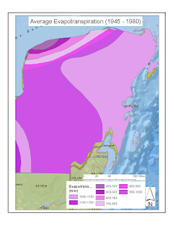
The next step was to check into actual climate data, particularly since the peninsula is known for being more on the arid side; so I got an evapo-transpiration map and a precipitation map to illustrate, generally speaking, a water budget for the region.
Here's where it begins to look bleak for them in regards to climate. Judging by the areas from decades of data, there's approximately a small surplus of around 100-400mm/year of rain, depending on location. This means that as their population grew, so did their need for crop yield, and the more they tore down the forests to make space for crops, the more the land eroded, the climate became hotter and drier, and the less rain they got in the long run.Final points of discussion:
- The Yucatan Peninsula definitely has a propensity for drought.
- The most vulnerable populations are going to be further south, in the higher elevations in particular, as they not only lack as much access to rainwater collections such as cenotes, but also the groundwater table.
- An interesting idea to look into for furthering research into causal factors would be looking at autogenic succession to see where various areas systems are in their development to get an idea where and to what extent, the Mayans may have damaged the land.
- Topography definitely matters in regards to water resources, but also in disasters as well. With no hurricane protection outside of relatively smaller reef zones off the coast, hurricanes have run straight over the peninsula. This could have been a huge problem for the Mayans through lost crop yields to the storms damaging winds.
A representation of autogenic succession for reference:


Comments
Post a Comment